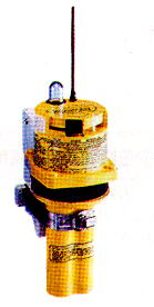
The SATFIND-406TM GPIRBTM (Global Position Indicating Radio Beacon) is the first in a new category of Lifesaving emergency equipment, developed to speed up search and rescue operations for mariners and vessels in distress. By incorporating the Latest in GPS and 406 MHz EPIRB technology, GPIRB provides extraordinary precision to the emergency distress signal, greatly increasing mariners' chances of recovery and survival. And because the SATFIND-406 GPIRB utilises both COSPAS-SARSAT and GEOSAR satellite networks, the first alert time for the entire globe is reduced to a few minutes.
Before the GPIRB, all 406 EPIRBs relied on computations using the Doppler shift in the beacons' 406 MHz distress signal frequency which occurs as the COSPAS-SARSAT satellites approach and recede in overhead orbits. The accuracy of those computations depends upon the number of signal-bursts received by these polar-orbiting satellites.
Accurate positioning is enhanced by the satellites passing directly overhead because that trajectory produces the highest number of receivable signal-bursts. The satellites orbit at about 600 miles above the earth in polar orbit. This distance gives each satellite an east-west swath of approximately 3,000 miles and an orbital time of 105 minutes. Each of the satellites travels in its own unique orbit with a satellite passing over the Poles every 20 minutes on average. At the equator, two or three hours may elapse before the next satellite pass.

To improve the coverage of equatorial waters, a second network of satellites has been deployed. Geostationary Search and Rescue (GEOSAR) satellites are equipped with 406 MHz transponders, and each satellite has a "foot- print" that provides coverage from 70" north to 700 south Latitudes and east-west 75" from their respective Location. Currently, there are four satellites in the GEOSAR network, stationed at 75" West, 135" West, 74" East and 93.5" East, producing better than 95% coverage of the temperate waters of the world. Additional satellite launches are planned. GEOSAR, when combined with COSPAS-SARSAT, gives the GPIRB a distinct advantage: it provides almost instantaneous recognition virtually anywhere on the globe.
The GPIRB is a very smart beacon because of its onboard GPS engine. When a GPIRB is activated, the GPS Locates itself and, after verifying acceptable parameters of position accuracy, Loads its current position digitally into the transmission "sentence" for broadcast to the satellites. Once this position information has been Loaded, the GPS shuts down to conserve power. Every 20 minutes, it will restart, relocate itself, Load the updated position information, and then shut down again. While GEOSAR relies on this input to "Locate" the distress signal, COSPAS-SARSAT satellites can also receive and relay GPS co-ordinates as well as the standard 406 MHz transmissions. The SATFIND-406 GPIRB is the first approved EPIRB that can send this data.
Location precision increases to within the GPS C/A code accuracy of 100 meters, versus more than a kilometre without GPS. The higher degree of accuracy makes helicopter rescues more cost- and time-effective. The GPIRB can improve rescue efforts in several other ways. The Rescue Co-ordination Centre (RCC) can calculate drift; this can save considerable search time by dispatching rescuers towards a computed recovery point. GPS data also reduces uncertainty over false alarms. Nothing on the market today can match the talent of the SATFIND-406 GPIRB from Northern Airborne Technology. By taking the "search" out of search and rescue, N.A.T.'s unique GPIRB is a true innovation in the field of marine emergency equipment and safety.
Carrying one could save your Life.