There are two types of LUTs in the Cospas-Sarsat System, those which are designed to operate with the LEOSAR satellite constellation are referred to as LEOLUTs, and those which operate with the GEOSAR satellite constellation are referred to as GEOLUTs.
LEOLUT and GEOLUT operators are expected to provide the SAR community with reliable alert and location data, without restriction on use and distribution. The Cospas-Sarsat Parties providing and operating the space segment supply LEOLUT and GEOLUT operators with System data required to operate their LUTs. To ensure that data provided by LUTs are reliable and can be used by the SAR community on an operational basis, Cospas-Sarsat has developed LUT performance specifications and procedures. Copies of the LEOLUT and GEOLUT specifications and commissioning standards are available for downloading from this web site.
The configuration and capabilities of each LEOLUT may vary to meet the specific requirements of the participating countries, but the Cospas and Sarsat LEOSAR spacecraft downlink signal formats ensure inter operability between the various spacecraft and all LEOLUTs meeting Cospas-Sarsat specifications.
The capability of a LEOLUT is determined, for the most part, by the LEOSAR satellite channels it was designed to process. There are a possible 4 channels that may, depending upon the specific satellite being tracked, be available for processing. Some satellites support all the channels listed below, and some only support a limited set of them.
For the 121.5 MHz, 243 MHz and 406 MHz signals received via their respective SARR channel, each transmission is detected and the Doppler information calculated. A beacon position is then determined using this data. In the case of 406 MHz distress beacons, the LUT is also able to provide identification information associated with the beacon.
Processing the SARP channel 2400 bps data (i.e. those generated from 406 MHz transmissions) is relatively straightforward since the Doppler frequency is measured and time-tagged onboard the spacecraft. All 406 MHz data received from the satellite memory on each pass can be processed within a few minutes of pass completion.
In order to improve location accuracy, a correction of the satellite ephemeris is produced each time the LUT receives a satellite signal. The downlink carrier is monitored to provide a Doppler signal using the LUT location as a reference, or highly stable 406 MHz calibration beacons at accurately known locations are used to update the ephemeris data.
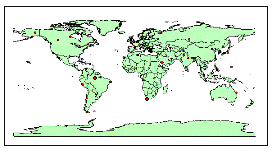
The map below shows the locations of LUTs:
The list below shows the locations of LUTs all over the world: